Sunset Table Mountain print by well known South African artist, Ina Grobbelaar. Table Mountain has recently been selected as one of the new Seven Wonders of the World. From an international viewpoint, Table Mountain has become the most prominent tourist feature of South Africa. Ina is awed by the fantastic abundance of wild flowers…
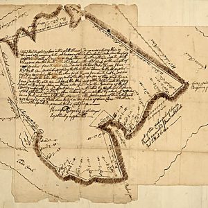
Survey of AnnapolisRidgely, Henry. CREATED PUBLISHED 1690This beautiful antique map reproduction is printed on heavy acid-free stock with fade proof inks and is excellent for framingSurvey of AnnapolisRidgely, Henry. CREATED PUBLISHED 1690 This beautiful antique map reproduction is printed on heavy acid-free stock with fade proof inks and is excellent for framing 20 W x…
Syracuse, New York by H.H. Bailey, 1874.This beautiful antique map reproduction is printed on heavy acid-free stock with fade proof inks and is excellent for framing. 32 W x 23 H
TAB is a diet cola soft drink created and produced by The Coca-Cola Company, introduced in 1963. Coca-Cola s first diet drink, Tab was notably popular throughout the 1960s and 1970s Made in South Africa & Imported by Aubergine Foods.
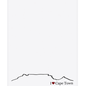
These 100% cotton tea towels are locally inspired and made in Cape Town, South Africa. Table Mountain is one of South Africa s national treasures. Makes the perfect hostess gift.
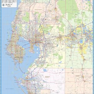
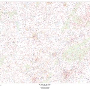
Our Tampa Bay Area wall map shows the area within 40 miles of downtown Tampa, including the communities of St Petersburg, Clearwater, Largo, Sarasota, Brandon, Riverview, Palm Harbor, Spring Hill, Bradenton, Pinellas Park, and Dunedin, as well as Hernando County, Pasco County, Pinellas County, Hillsborough County, Manatee County, and parts of Sarasota County, Desoto County,…
50 bags of Flavor. If you re looking for something to really tea-se your tastebuds, we ve got just the brew! Tanganda Tea is lovingly crafted with a unique blend of flavors, so you can embark on a zesty and zingy adventure right in your cup. Our 50-bag collection means you can keep the joy of…
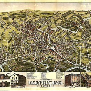
Taunton, Mass. by O.H. Bailey & Co., 1875This beautiful antique map reproduction is printed on heavy acid-free stock with fade proof inks and is excellent for framing. 30 W x 22 H
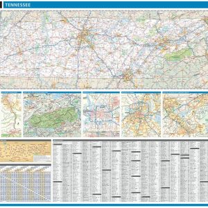
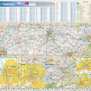
Laminated with Hanging Rails 60 W x 46 H Index of Counties and Cities Fully Indexed Counties, Cities, Mileage Chart Inset Maps of All Major Cities Free Shipping! This map is rolled and shipped in a sturdy cardboard tube.
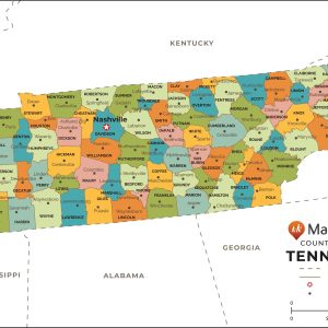
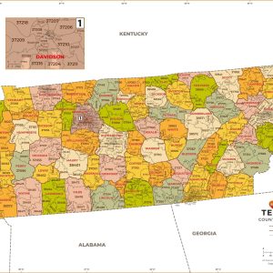
This map has been created and designed for reference or business use. Clear and clean colors & fonts matched with cartographic research makes this map of Tennessee Counties Map easily readable and useful. The map shows the 95 counties of Tennessee and their borders across the Volunteer State. This map is rolled and shipped in…
This colorful, easy-to-read state map of Tennessee identifies all major thoroughfares, secondary roads, freeway interchanges, rest areas, distance markers, landmarks, recreational areas, and more. Shaded relief on the state map provides a three-dimensional sense of Tennessee s topography. Detailed city inset maps of Chattanooga, Knoxville, Memphis, and Nashville are based on the latest street information…
This map of Tennessee shows ZIP codes overlaid on a road map. Base map features include county boundaries, major road network features, and state and national parks and conservation areas. This map is rolled and shipped in a sturdy cardboard tube.
This map has been created and designed for business or reference use. Clear and clean colors & fonts matched with cartographic research makes this Tennessee Zip Code Map with Counties easily readable and useful. The map shows the 95 counties of Tennessee and the borders of the 627 zip codes across the Volunteer State. This…
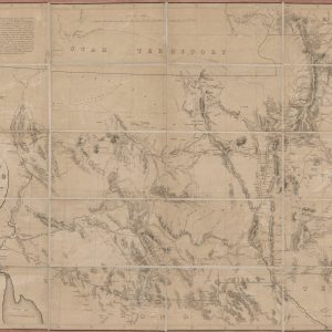
This historic map reproduction is printed on heavy acid-free stock with fade proof inks and is excellent for framing. The map covers territory between Utah and Mexico, from the Colorado River to the Liano Estacado; shows trails and wagon roads, forts, expeditions and explorations of the Southwest; names places and known rivers and mountain ranges….