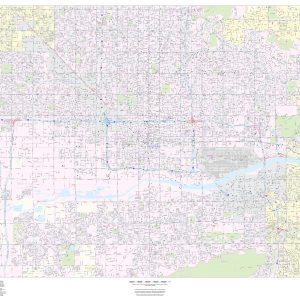
This portrait-oriented map of central Phoenix, Arizona shows detailed street level information including extensive street labeling. Ideal for planning of deliveries, home services, sales territories, real estate and much more. Base map features include all roads with major roads and highways labelled; neighborhood names; railways; high level land use such as parks and recreation areas,…
This detailed reference map combines two maps in one – a regional map of the Phoenix metropolitan area plus a street-level map of downtown Phoenix. The regional map depicts the area s cities and towns, highways and roads, and a variety of points of interest. Scottsdale, Tempe, and Mesa are among the cities near Phoenix…
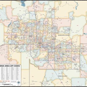
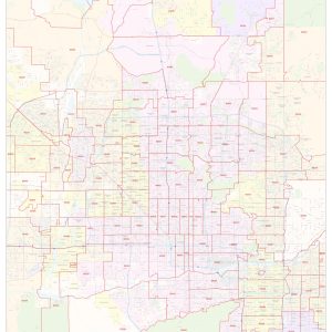
Our Phoenix Metro Area ZIP Code Map highlights zip code areas within a 70 mile wide by 60 mile high region of central Arizona. The perfect tool for visualizing the big picture for the entire Phoenix Metro area, each zip code is colorized and labeled for quick identification. The map also shows counties, communities, and…
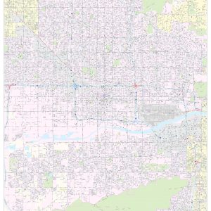
This landscape-oriented map of central Phoenix, Arizona shows detailed street level information including extensive street labeling. Ideal for planning of deliveries, home services, sales territories, real estate and much more. Base map features include all roads with major roads and highways labelled; neighborhood names; railways; high level land use such as parks and recreation areas,…
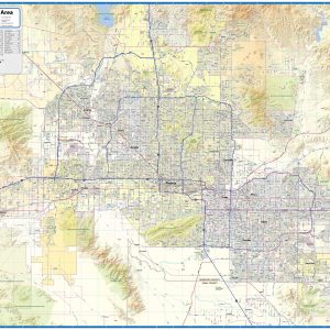
Laminated or paper wall map of the Phoenix metro Area showing locations within 50 miles of downtown Phoenix, including Chandler, Gilbert, Glendale, Mesa, Peoria, Scottsdale, Surprise, Tempe, Queen Creek, Buckeye, Goodyear, El Mirage, Apache Junction, Sun City, Avondale, among other communities in the Valley of the Sun. Features shown include cities, towns, major roads and highways, zip codes, and major points of…
This map of Phoenix shows ZIP code areas overlaid on a road map. Ideal for planning of deliveries, home services, sales territories, real estate and much more. Base map features include all roads with major roads and highways labelled; neighborhood names; railways; and high level land use such as parks and recreation areas, industrial areas…
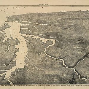
Pictorial map of the seat of war, showing parts of the states of Maryland, Delaware, Virginia, and North CarolinaThis beautiful antique map reproduction is printed on heavy acid-free stock with fade proof inks and is excellent for framing. 22 W x 16 H
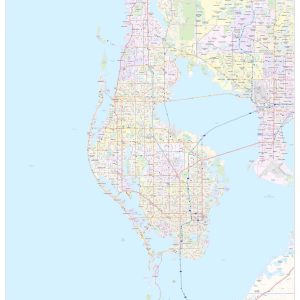
This map of Pinellas County, Florida shows regional level information. Base map features include highways and major roads with labelling; neighborhood names; railways; high level land use such as parks and recreation areas, industrial areas and hospital campuses; and a selection of points of interest including transportation hubs like airports and train stations, tourist information,…
These pink protea 100% cotton tea towels from our I Love It Here collection are the perfect addition to complement your kitchen. Matching table runners and soft pots available. Can be used as a tea towel, tray cloth or perfect for framing. 22 x 14 Available in a variety of botanical and floral prints all…
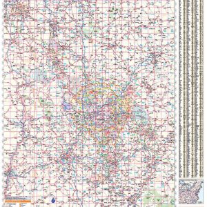
Wall map of the Pittsburgh Metro Area showing locations within 35 – 60 miles of downtown Pittsburgh, including all of southwestern Pennsylvania. The map covers Allegheny, Lawrence, Butler, Armstrong, Indiana, Westmoreland, Fayette, Washington, Greene, and Butler Counties, as well as the immediate adjacent areas of Pennsylvania, West Virginia, Ohio, and Maryland. Features shown include cities,…
Rand McNally s regional wall map of Pittsburgh is ideal for anyone needing a comprehensive representation of the area for planning, routing, or reference. It s a great choice for business and sales strategy, urban development, social work outreach, education, and marketing. Pittsburgh residents, businesses, and government offices are sure to find this wonderful reference…
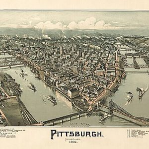
Pittsburgh, Pennsylvania by T. M. Fowler, 1902This beautiful antique map reproduction is printed on heavy acid-free stock with fade proof inks and is excellent for framing. 24 W x 16 H
Plan de New-York et des environs, levé par Montrésor, ingénieur en 1775.This beautiful antique map reproduction is printed on heavy acid-free stock with fade proof inks and is excellent for framing. 20 W x 24 H
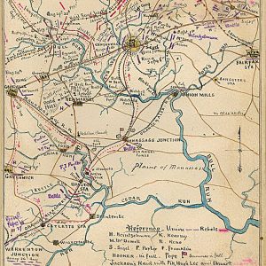
Plan of 2nd battle of Bull Run Shewing movements of troops from 27 Aug. to Sept. 1 by Robert Knox SnedenThis beautiful antique map reproduction is printed on heavy acid-free stock with fade proof inks and is excellent for framing. 12 W x 16 H
Plan of Alexandria, Virginia, 1862This beautiful antique map reproduction is printed on heavy acid-free stock with fade proof inks and is excellent for framing. 21 W x 16 H
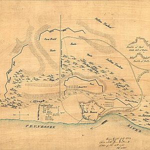
Plan of Fort Henry and its outworksThis beautiful antique map reproduction is printed on heavy acid-free stock with fade proof inks and is excellent for framing. 21 W x 16 H