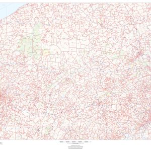
This map of Pennsylvania shows ZIP codes overlaid on a road map. Base map features include municipality and county boundaries, major road network features, and state and national parks and conservation areas. This map is rolled and shipped in a sturdy cardboard tube.
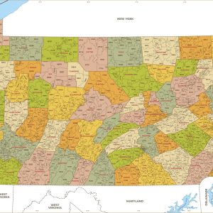
This map has been created and designed for business or reference use. Clear and clean colors & fonts matched with cartographic research makes this Pennsylvania Zip Code Map with Counties easily readable and useful. The map shows the 67 counties of Pennsylvania and the borders of the over 1,700 zip codes across the Keystone State….
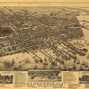
Pensacola, Fla. county seat of Escambia County, 1885 This beautiful antique map reproduction is printed on heavy acid-free stock with fade proof inks and is excellent for framing. 26 W x 20 H
Perspective map of Bedford City, Virginia, by H. Wellge, 1891This beautiful antique map reproduction is printed on heavy acid-free stock with fade proof inks and is excellent for framing. 26 W x 18 H
This beautiful antique map reproduction is printed on heavy acid-free stock with fade proof inks and is excellent for framing. This map is indexed for points of interest. Copyright Henry Wellge & Co., 1887 Size: 32 × 21
Perspective map of Missoula, Montana by American Publishing Co., 1891This beautiful antique map reproduction is printed on heavy acid-free stock with fade proof inks and is excellent for framing. 29 W x 19 H
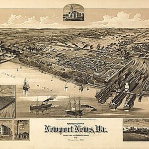
Perspective map of Newport News, Virginia by American Publishing Co., 1891This beautiful antique map reproduction is printed on heavy acid-free stock with fade proof inks and is excellent for framing. 28 W x 18 H
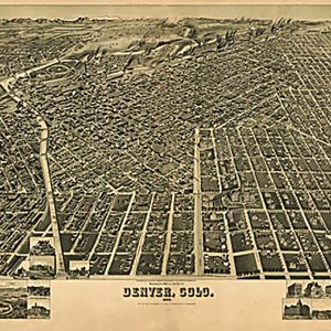
Perspective map of the city of Denver, Colo. 1889. H. Wellge, des. Wellge, H. (Henry)CREATED PUBLISHED Milwaukee, American Publishing Co. 1889This beautiful antique map reproduction is printed on heavy acid-free stock with fade proof inks and is excellent for framing. 36 W x 23 H
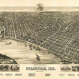
Perspective map of the city of Evansville, Indiana by Henry Wellge, 1888This beautiful antique map reproduction is printed on heavy acid-free stock with fade proof inks and is excellent for framing. 35 W x 23 H
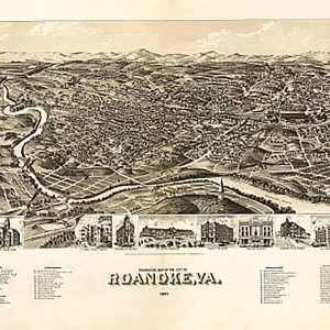
Perspective map of the city of Roanoke, Virginia by American Publishing Co., 1891This beautiful antique map reproduction is printed on heavy acid-free stock with fade proof inks and is excellent for framing. 32 W x 20 H
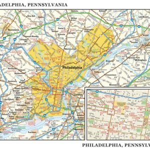
Rand McNally s regional wall map of Philadelphia is ideal for anyone needing a comprehensive representation of the area for planning, routing, or reference. It s a great choice for business and sales strategy, urban development, social work outreach, education, and marketing. Philly residents, businesses, and government offices are sure to find this wonderful reference…
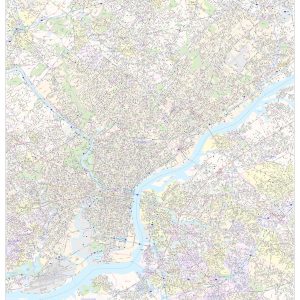
This map of Philadelphia County, Pennsylvania shows street level information including street labeling. Base map features include all roads with major roads and highways labelled; neighborhood names; railways; high level land use such as parks and recreation areas, industrial areas and hospital campuses; and a variety of points of interest including libraries, stadiums, museums, border…
This detailed reference map combines two maps in one – a map of the greater Philadelphia area plus a street-level map of historic, downtown Philadelphia. The metropolitan map shows the area s cities and towns, highways and roads, and a variety of points of interest. The map includes the surrounding suburban cities in Pennsylvania and…
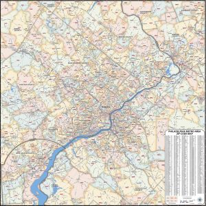
Our laminated Philadelphia Metro Area ZIP Code Map highlights zip code areas within the metro Philadelphia area. The perfect tool for visualizing the big picture for the entire Philadelphia Metro area, each zip code is colorized and labeled for quick identification. The map also shows counties, communities, and major roads. An index of zip codes…
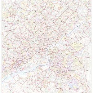
This map of Philadelphia shows ZIP code areas overlaid on a road map. Ideal for planning of deliveries, home services, sales territories, real estate and much more. Base map features include all roads with major roads and highways labelled; neighborhood names; railways; and high level land use such as parks and recreation areas, industrial areas…