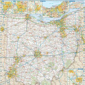
This colorful, easy-to-read state map of Ohio identifies all major thoroughfares, secondary roads, freeway interchanges, route numbers, landmarks, recreational areas, and more. Shaded relief on the state map provides a three-dimensional sense of Ohio s topography. Detailed inset maps of Akron, Canton, Cincinnati, Cleveland, Columbus, Dayton, Springfield, Toledo and Youngstown are based on the latest…
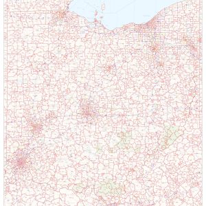
This map of Ohio shows ZIP codes overlaid on a road map. Base map features include municipality and county boundaries, major road network features, and state and national parks and conservation areas. This map is rolled and shipped in a sturdy cardboard tube.
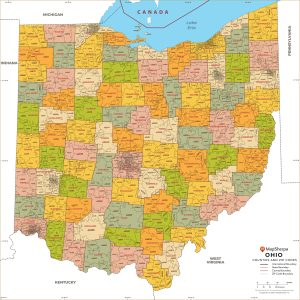
This map has been created and designed for business or reference use. Clear and clean colors & fonts matched with cartographic research makes this Ohio Zip Code Map with Counties easily readable and useful. The map shows the 88 counties of Ohio and the borders of the over 1,000 zip codes across the Buckeye State….
Laminated with Hanging Rails 60 W x 46 H Index of Counties and Cities Fully Indexed Counties, Cities, Mileage Chart Inset Maps of All Major Cities Free Shipping! This map is rolled and shipped in a sturdy cardboard tube.
Our Oklahoma City Metro Area wall map shows the area within 25 – 30 miles of downtown Oklahoma City, including the communities of Shawnee, Bethany, Chandler, Chickasha, Choctow, Del City, Edmond, El Reno, Harrah, Jones, McLoud, Midwest City, Moore, Mustang, Newcastle, Nichols Hills, Nicoma Park, Noble, Norman, Piedmont, Purcell, Spencer, Tuttle, The Village, Warr Acres,…
Oklahoma lies where the sweeping prairies of the Great Plains meet the western shoulder of the Ozark Mountains. This wall map illustrates The Sooner State’s array of country roads and recreation opportunities. If outdoor adventure and recreation is your thing, this is the map for you. This map is loaded with points of interest from…
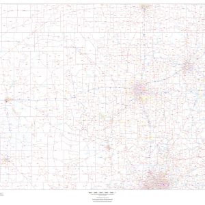
Wall map of Oklahoma, showing counties, towns, cities, villages, major roads and highways. Includes community index. This map comes in a variety of sizes and finishing options. It is shipped rolled in a sturdy cardboard tube.
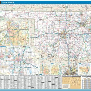
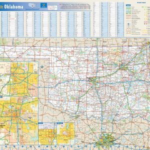
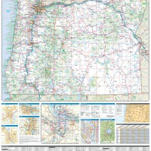
This colorful, easy-to-read state map of Oklahoma identifies all major thoroughfares, secondary roads, freeway interchanges, rest areas, distance markers, landmarks, recreational areas, and more. Shaded relief on the state map provides a three-dimensional sense of Oklahoma s topography. Detailed inset maps of Lawton, Oklahoma City, Stillwater, and Tulsa are based on the latest street information…
This map of Oklahoma shows ZIP codes overlaid on a road map. Base map features include county boundaries, major road network features, and state and national parks and conservation areas. This map is rolled and shipped in a sturdy cardboard tube.
Get a gently fragranced, semi-conditioning washing powder that removes even the toughest stains while softening your garments and linens. This auto-washing powder cleans and brightens your clothes Even the toughest stains can be removed using this auto washing powder detergent since it deeply penetrates the fibres of your clothing. This semi-conditioning powder detergent effectively cleans while removing…
Rand McNally s ProSeries wall map of Orange County is ideal for anyone needing a comprehensive representation of the area for planning, routing, or reference. It s a great choice for business and sales strategy, urban development, social work outreach, education, and marketing. Note: This map is not available for gift wrapping. Please allow 7-10…
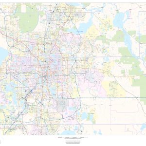
This map of Orange County, Florida shows regional level information. Base map features include highways and major roads with labelling; neighborhood names; railways; high level land use such as parks and recreation areas, industrial areas and hospital campuses; and a selection of points of interest including transportation hubs like airports and train stations, tourist information,…
Laminated with Hanging Rails 46 W x 60 H Index of Counties and Cities Fully Indexed Counties, Cities, Mileage Chart Inset Maps of All Major Cities Free Shipping! This map is rolled and shipped in a sturdy cardboard tube.
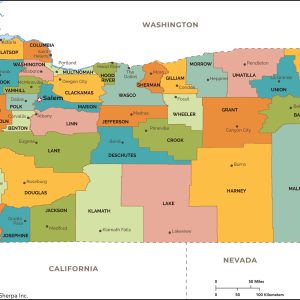
This map has been created and designed for reference or business use. Clear and clean colors & fonts matched with cartographic research makes this map of Oregon Counties Map easily readable and useful. The map shows the 36 counties of Oregon and their borders across the Beaver State. This map is rolled and shipped in…
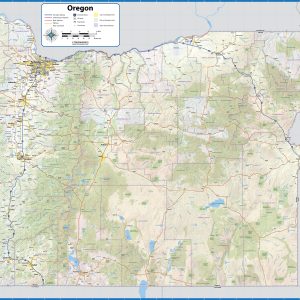
With its rugged but peaceful Pacific Coast and inland features like Crater Lake and myriad mountain peaks and hidden waterfalls, Oregon is a favorite destination for travelers across the American West. This wall map illustrates the public lands and recreation hotspots across The Beaver State. If outdoor adventure and recreation is your thing, this is…
Wall map of Oregon showing counties, towns, cities, villages, major roads and highways. Includes community index. This map comes in a variety of sizes and finishing options. It is shipped rolled in a sturdy cardboard tube.