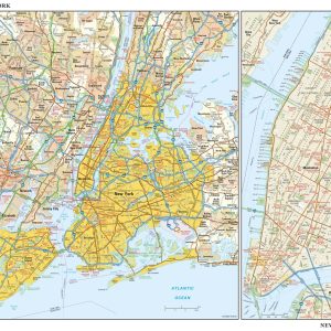
Our New York Metro Area Wall Map shows the area within approx. 30 miles from midtown Manhattan, including northeastern New Jersey, Westchester and Rockland Counties, parts of Fairfield County, CT, and Nassau County, Long Island. The map shows states, counties, towns, cities, boroughs, major roads, highways, and major points of interest. This map is rolled…
This detailed reference map combines two maps in one – a regional map of New York that includes all five boroughs and northeastern New Jersey plus a street-level map of Midtown and Lower Manhattan. The regional map – including all of Manhattan, Brooklyn, Queens, Bronx, and Staten Island – shows the area s cities and…
New York Counties Wall Map Beautifully illustrated with subtle earth tone hues, the detail is highly legible with borders clearly defined. In classic Atlas style, this map can be used for general reference, to track current events, or as a piece of art. Decorators will find the color scheme works beautifully with dark wood furniture…
This map of New York County, New York shows detailed street level information including extensive street labeling. Ideal for planning of deliveries, home services, sales territories, real estate and much more. Base map features include all roads with major roads and highways labelled; neighborhood names; railways; high level land use such as parks and recreation…
This map has been created and designed for reference or business use. Clear and clean colors & fonts matched with cartographic research makes this map of the 62 New York counties easily readable and useful. This map comes rolled and ships in a sturdy cardboard tube.
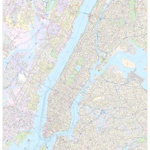
This portrait-oriented map of central New York City, New York shows detailed street level information including extensive street labeling. Ideal for planning of deliveries, home services, sales territories, real estate and much more. Base map features include all roads with major roads and highways labelled; neighborhood names; railways; high level land use such as parks…
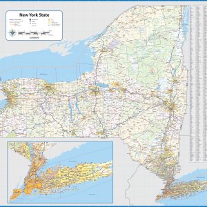
Wall map of New York, showing counties, towns, cities, villages, major roads and highways. Includes community index. This map comes in a variety of sizes and finishing options. It is shipped rolled in a sturdy cardboard tube.
New York Wall Map Beautifully illustrated with subtle earth tone hues, the detail is highly legible with borders clearly defined. In classic Atlas style, this map can be used for general reference, to track current events, or as a piece of art. Decorators will find the color scheme works beautifully with dark wood furniture and…
This map of New York shows ZIP codes overlaid on a road map. Base map features include county boundaries, major road network features, and state and national parks and conservation areas. This map is rolled and shipped in a sturdy cardboard tube.
This map has been created and designed for reference or business use. Clear and clean colors & fonts matched with cartographic research makes this map of the 62 New York counties easily readable and useful. This map comes rolled and ships in a sturdy cardboard tube.
Newton Centre, Massachusetts by O.H. Bailey & Co, 1897This beautiful antique map reproduction is printed on heavy acid-free stock with fade proof inks and is excellent for framing. 25 W x 20 H
Newton, Massachusetts, Wards 1 and 7 by O.H. Bailey & Co., 1897This beautiful antique map reproduction is printed on heavy acid-free stock with fade proof inks and is excellent for framing. 26 W x 18 H