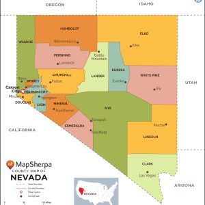
This map has been created and designed for reference or business use. Clear and clean colors & fonts matched with cartographic research makes this map of Nevada Counties Map easily readable and useful. The map shows the 16 counties of Nevada and their borders across the Silver State. This map is rolled and shipped in…
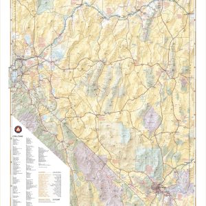
Nevada’s desert landscapes can seem desolate, but there are world-class recreation oases throughout including Great Basin National Park, Lake Tahoe, Las Vegas, and the Black Rock Desert. This wall map illustrates the diversity of public lands and roadways that make The Silver State a delight for travelers looking for something different. If outdoor adventure and…
Wall map of Nevada, showing counties, towns, cities, villages, major roads and highways. Includes community index. This map comes in a variety of sizes and finishing options. It is shipped rolled in a sturdy cardboard tube.
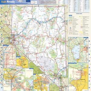
This colorful, easy-to-read state map of Nevada identifies all major thoroughfares, secondary roads, freeway interchanges, rest areas, distance markers, landmarks, recreational areas, and more. Shaded relief on the state map provides a three-dimensional sense of Nevada’s topography. Detailed city inset maps of Carson City, Laughlin, Las Vegas, and Reno are based on the latest street…
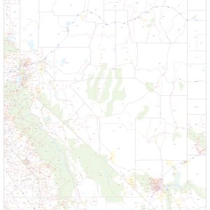
This map of Nevada shows ZIP codes overlaid on a road map. Base map features include county boundaries, major road network features, and state and national parks and conservation areas. This map is rolled and shipped in a sturdy cardboard tube.
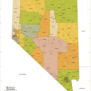
This map has been created and designed for business or reference use. Clear and clean colors & fonts matched with cartographic research makes this Nevada Zip Code Map with Counties easily readable and useful. The map shows the 16 counties of Nevada and the borders of the 159 zip codes across the Silver State. This…
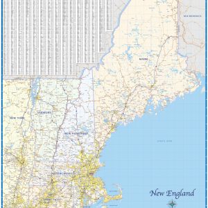
Regional road map covering the 6 New England states – Maine, Vermont, New Hampshire, Massachusetts, Connecticut, and Rhode Island. Features shown are cities, counties, major roads and highways. A city index is included. This map comes in a variety of sizes and finishing options. It is shipped rolled in a sturdy cardboard tube.
These colorful, easy-to-read state maps of New Hampshire and Vermont identify all major thoroughfares, secondary roads, freeway interchanges, rest areas, distance markers, landmarks, recreational areas, and more. Shaded relief on the state maps provides a three-dimensional sense of the topography. Detailed city inset maps of Concord, Manchester, Nashua, Portsmouth, Rochester, Burlington, and Montpelier are based…
Laminated with Hanging Rails 46 W x 6 H Index of Counties and Cities Fully Indexed Counties, Cities, Mileage Chart Inset Maps of All Major Cities Free Shipping! This map is rolled and shipped in a sturdy cardboard tube.
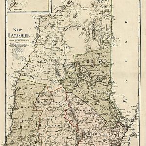
New Hampshire entworfen von D. F. Sotzmann, 1796.This beautiful antique map reproduction is printed on heavy acid-free stock with fade proof inks and is excellent for framing. 18 W x 27 H
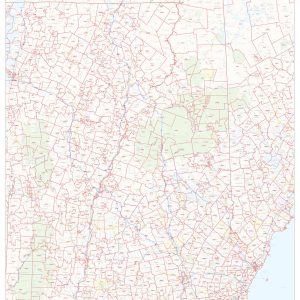
This map of New Hampshire shows ZIP code areas overlaid on a road map. Ideal for planning of deliveries, home services, sales territories, real estate and much more. Base map features include all roads with major roads and highways labelled, municipality and county boundaries, neighborhood names, railways, and high level land use such as parks…
Laminated with Hanging Rails 46 W x 60 H Index of Counties and Cities Fully Indexed Counties, Cities, Mileage Chart Inset Maps of All Major Cities Free Shipping! This map is rolled and shipped in a sturdy cardboard tube.
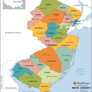
This map has been created and designed for reference or business use. Clear and clean colors & fonts matched with cartographic research makes this map of New Jersey Counties Map easily readable and useful. The map shows the 21 counties of New Jersey and their borders across the Garden State. This map is rolled and…
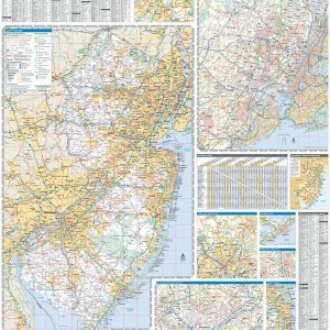
Wall map of New Jersey, showing counties, towns, cities, villages, major roads and highways. Includes community index. This map comes in a variety of sizes and finishing options. It is shipped rolled in a sturdy cardboard tube.
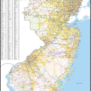
This colorful, easy-to-read state map of New Jersey identifies all major thoroughfares, secondary roads, freeway interchanges, rest areas, distance markers, landmarks, recreational areas, and more. Shaded relief on the state map provides a three-dimensional sense of New Jersey’s topography. Detailed city inset maps of Atlantic City and Trenton are based on the latest street information…
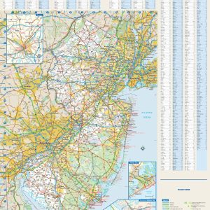
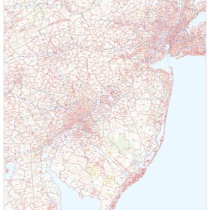
This map of New Jersey shows ZIP code areas overlaid on a road map. Ideal for planning of deliveries, home services, sales territories, real estate and much more. Base map features include all roads with major roads and highways labelled, municipality and county boundaries, neighborhood names, railways, and high level land use such as parks…