This map has been created and designed for reference or business use. Clear and clean colors & fonts matched with cartographic research makes this map of Mississippi Counties Map easily readable and useful. The map shows the 82 counties of Mississippi and their borders across the Magnolia State. This map is rolled and shipped in…
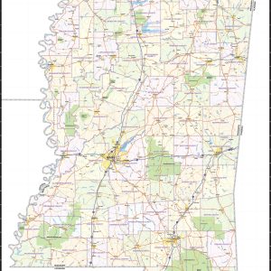
Wall map of Mississippi, showing counties, towns, cities, villages, major roads and highways. A community index is included. This map comes in a variety of sizes and finishing options. It is shipped rolled in a sturdy cardboard tube.
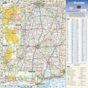
This colorful, easy-to-read state map of Mississippi identifies all major thoroughfares, secondary roads, freeway interchanges, rest areas, distance markers, landmarks, recreational areas, and more. Shaded relief on the state map provides a three-dimensional sense of Mississippi’s topography. Detailed city inset maps of Biloxi Gulfport, Hattiesburg, Jackson and Vicksburg are based on the latest street information…
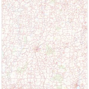
This map of Mississippi shows ZIP codes overlaid on a road map. Base map features include municipality and county boundaries, major road network features, and state and national parks and conservation areas. This map is rolled and shipped in a sturdy cardboard tube.
This map has been created designed for business or reference use. Clear and clean colors & fonts matched with cartographic research makes this Mississippi Zip Code Map with Counties easily readable and useful. The map shows the 82 counties of Mississippi and the borders of the 423 zip codes across the Magnolia State. This map…
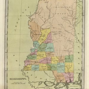
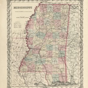
This beautiful antique map reproduction is printed on heavy acid-free stock with fade proof inks and is excellent for framing. The map shows the tribal lands of the Chickasaws and Choctaws. Copyright 1835 Size: 12 × 15
This beautiful antique map reproduction is printed on heavy acid-free stock with fade proof inks and is perfect for framing. The maps shows drainages, counties, townships, roads, railroads, and more. Copyright J.H. Colton & Co., 1855 Size: 15 × 18
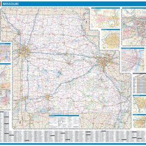
Laminated with Hanging Rails 60 W x 46 H Index of Counties and Cities Fully Indexed Counties, Cities, Mileage Chart Inset Maps of All Major Cities Free Shipping! This map is rolled and shipped in a sturdy cardboard tube.
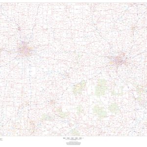
Wall map of Missouri, showing counties, towns, cities, villages, major roads and highways. A community index is included. This map comes in a variety of sizes and finishing options. It is shipped rolled in a sturdy cardboard tube.
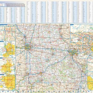
This colorful, easy-to-read state map of Missouri identifies all major thoroughfares, secondary roads, freeway interchanges, rest areas, distance markers, landmarks, recreational areas, and more. Shaded relief on the state map provides a three-dimensional sense of Missouri s topography. Detailed city inset maps of Branson, Columbia, Jefferson City, Joplin, Kansas City, St. Louis, St. Joseph, and…
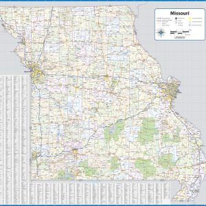
This map of Missouri shows ZIP codes overlaid on a road map. Base map features include county boundaries, major road network features, and state and national parks and conservation areas. This map is rolled and shipped in a sturdy cardboard tube.
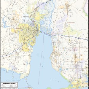
Our Mobile Metro Area wall map shows the area within 20 miles of downtown Mobile, including the communities of Daphne, Prichard, Chickasaw, Saraland, Tillmans Corner, Bayou La Batre, Gulf Shores, Foley, Robertsdale, and Bay Minette, among others. Features shown include cities, towns, counties, highways and major and secondary roads, zip codes, and major points of…
Treat yourself to a bubbly slice of joy with this 750ml bottle of lekker Monis Sparkling Red Grape Juice. Nothing beats a refreshing soda without the guilt of added sugars – so cheers to a guilt-free indulgence! made in South Africa.
Treat yourself to a bubbly slice of joy with this 750ml bottle of lekker Monis Sparkling White Grape Juice. Nothing beats a refreshing soda without the guilt of added sugars – so cheers to a guilt-free indulgence! made in South Africa.
Laminated with Hanging Rails 46 W x 60 H Index of Counties and Cities Fully Indexed Counties, Cities, Mileage Chart Inset Maps of All Major Cities Free Shipping! This map is rolled and shipped in a sturdy cardboard tube.
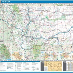
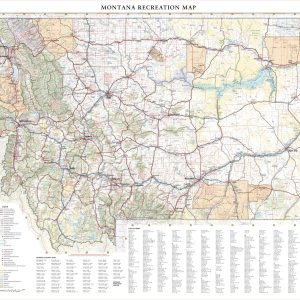
Montana covers a massive area (4th largest state in the USA) from its eastern Great Plains to the Rocky Mountains in the west. This wall map illustrates Big Sky County’s vast landscapes and scenic roads that connect world class destinations including Glacier and Yellowstone National Parks. If outdoor adventure and recreation is your thing, this…