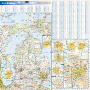
Wall map of Michigan, showing counties, towns, cities, villages, major roads and highways. The entire state, including both the Upper Peninsula and Lower Peninsula, is shown at the same scale. A community index is included. This map comes in a variety of sizes and finishing options. It is shipped rolled in a sturdy cardboard tube.
This colorful, easy-to-read state map of Michigan identifies all major thoroughfares, secondary roads, freeway interchanges, rest areas, distance markers, landmarks, recreational areas, and more. Shaded relief on the state map provides a three-dimensional sense of Michigan s topography. Detailed inset maps of Isle Royale National Park, Northwestern Michigan, Saginaw, Grand Rapids, Flint, Ann Arbor, Detroit,…
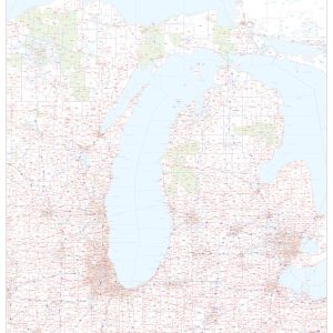
This map of Michigan shows ZIP codes overlaid on a road map. Base map features include county boundaries, major road network features, and state and national parks and conservation areas. This map is rolled and shipped in a sturdy cardboard tube.
Middle Tennessee by G. H. Blakeslee, 1863This beautiful antique map reproduction is printed on heavy acid-free stock with fade proof inks and is excellent for framing. 17 W x 22 H
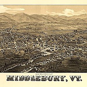
Middlebury, Vermont by L. R. Burleigh, c1886This beautiful antique map reproduction is printed on heavy acid-free stock with fade proof inks and is excellent for framing. 30 W x 16 H
Midland, Maryland drawn and published by T.M. Fowler, Morrisville, Pa.Fowler, T. M. 1842-1922. (Thaddeus Mortimer),NOTES Aerial view of village.Relief shown by shading and landform drawings.Includes inset view of Ocean village and illustrations of prominent buildings.This beautiful antique map reproduction is printed on heavy acid-free stock with fade proof inks and is excellent for framingMidland, Maryland…
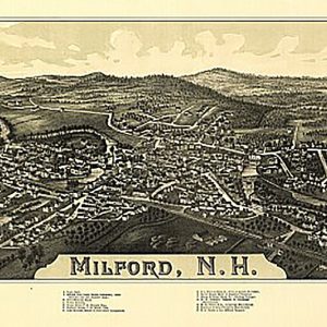
Milford, New Hampshire by L. R. Burleigh, c1886.This beautiful antique map reproduction is printed on heavy acid-free stock with fade proof inks and is excellent for framing. 33 W x 18 H
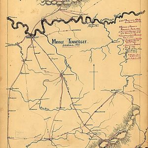
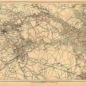
Military map of south-eastern Virginia by A. Lindenkohl, 1864This beautiful antique map reproduction is printed on heavy acid-free stock with fade proof inks and is excellent for framing. 32 W x 19 H
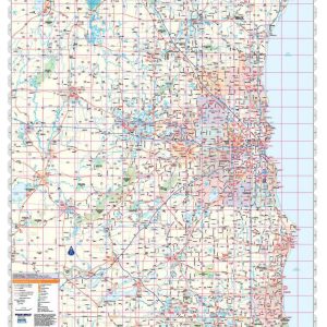
Wall map of the Milwaukee Metro Area showing locations within 40 – 60 miles of downtown Milwaukee, including the area from Fond du Lac and Sheboygan in the north to the Illinois state line in the south, and from Lake Michigan in the east to Janesville and Beloit in the west. Features shown include cities,…
Rand McNally s regional wall map of Milwaukee is ideal for anyone needing a comprehensive representation of the area for planning, routing, or reference. It s a great choice for business and sales strategy, urban development, social work outreach, education, and marketing. Milwaukee residents, businesses, and government offices are sure to find this wonderful reference…
Made from recycled paper, this popular wall mounted DIY African Kudu head in a brown Shweshwe print is a great gift for all ages. Flat-packed for convenient gift wrapping, and super easy to assemble. Suitable for all ages.Kids under 6 years may need a bit of help with assembly. No glue required. 10.5 W x 9.5 D x 15.75…
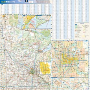
Laminated with Hanging Rails 46 W x 60 H Index of Counties and Cities Fully Indexed Counties, Cities, Mileage Chart Inset Maps of All Major Cities Free Shipping! This map is rolled and shipped in a sturdy cardboard tube.
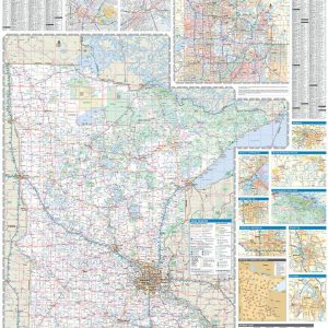
Wall map of Minnesota, showing counties, towns, cities, villages, major roads and highways. A community index is included. This map comes in a variety of sizes and finishing options. It is shipped rolled in a sturdy cardboard tube.
This colorful, easy-to-read state map of Minnesota identifies all major thoroughfares, secondary roads, freeway interchanges, rest areas, distance markers, landmarks, recreational areas, and more. Shaded relief on the state map provides a three-dimensional sense of Minnesota s topography. Detailed city inset maps of Duluth, Rochester and the Twin Cities are based on the latest street…
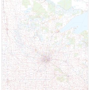
This map of Minnesota shows ZIP codes overlaid on a road map. Base map features include county boundaries, major road network features, and state and national parks and conservation areas. This map is rolled and shipped in a sturdy cardboard tube.
Laminated with Hanging Rails 46 W x 60 H Index of Counties and Cities Fully Indexed Counties, Cities, Mileage Chart Inset Maps of All Major Cities Free Shipping! This map is rolled and shipped in a sturdy cardboard tube.